|
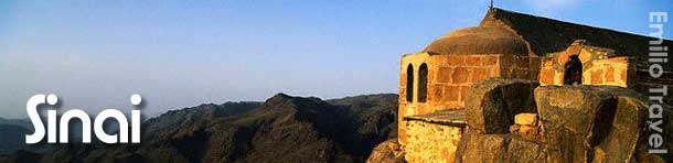
Sinai Peninsula is the corridor between Africa and Asia. In
Pharaonic times the "Way of Horus" & Land of Turquoise.
 Later it became the way of Moses and under the mountain where he
received the ten commandments is the monastery of St. Catherine.
The monastery got special protection from Prophet Mohammed in
year 625 and included in Unesco's World Heritage List in year
2002. Later it became the way of Moses and under the mountain where he
received the ten commandments is the monastery of St. Catherine.
The monastery got special protection from Prophet Mohammed in
year 625 and included in Unesco's World Heritage List in year
2002.
When the Holy Family sought protection in Egypt, they came via
the North Coast road - and for North African Muslims on
Pilgrimage to Mecca, this is their land road.
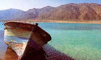
 The peninsula's unique nature matches it's history with the Red
Sea in south and the Mediterranean in north. The peninsula's unique nature matches it's history with the Red
Sea in south and the Mediterranean in north.
In-between 61,000 square kilometers of desert, mountains and
smaller oases. In south the mountains reign while a limestone
plateau covers the central area. In north the plateau slopes
down to Mediterranean palm beaches.
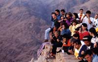
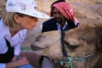
 Some few cities, but a majority of the population is wandering
Bedouins where the camel still is an essential part of the
society. Some few cities, but a majority of the population is wandering
Bedouins where the camel still is an essential part of the
society.
Safari to the Sinai peninsula ,the meeting place between the
continents of Africa and Asia takes you from ancient turquoise
mines to Bedouins in the mountain desert; from the ecosystems of
the coral reefs and coastal sand dunes to a majestic view over
Sinai from the top of Moses Mountain.
The most important Safari destinations:
Ain El Furtaga
16 km from Nuweiba by road. Palmy oasis at the crossroads of
trails to the Coloured Canyon, Wadi Ghazala and Ain Khudra
Oasis.
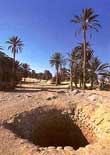
Ain Hudra Oasis
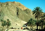 One of the loveliest oasis in Sinai. Nature has carved the
sandstone to fascinating shapes. The yellow and brown of the
desert canyon give way to green when reaching the Ain Hudra
Oasis. Here we can explore the big palm trees forest and the
gardens of olives, grapes and orange close to the spring of
water. Bedouins have their little houses on the slopes leading
up the mountain sides. One of the loveliest oasis in Sinai. Nature has carved the
sandstone to fascinating shapes. The yellow and brown of the
desert canyon give way to green when reaching the Ain Hudra
Oasis. Here we can explore the big palm trees forest and the
gardens of olives, grapes and orange close to the spring of
water. Bedouins have their little houses on the slopes leading
up the mountain sides.
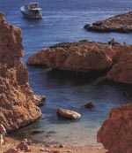
Ain Kid Oasis
14 km off the road between Sharm El Sheikh and Dahab; reached
via Wadi Kid, a red-walled canyon where a spring appears in
rainy years. The Oasis has a fresh-water well.
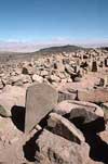
Nuwamis
Prehistoric site with 5550-year-old graves and inscriptions
Wadi Ghazala
Named after the gazelle deer living there, it links Ain El
Furtaga and Ain Hudra oasis. Acacia groves, dunes and gazelles
are to be seen there.
Hamam Faraoun
It lies 55 km south of Ras Sudr ( Pharaoh’s Bath)
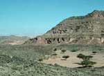
Wadi Widai
This area is a valley surrounded by Granite mountains of varying
colours and shapes
Abu Galum
 It is located in the north east of south Sinai, near by the Gulf
of Aqaba. It’s area measures 500 square kilometers It is located in the north east of south Sinai, near by the Gulf
of Aqaba. It’s area measures 500 square kilometers
Abu Galum is one of the picturesque nature reserves in the
country. With its high mountains, narrow sinuous valleys (wadis),
freshwater springs, coastal sand dunes, gravel alluvial fans,
raised fossil coral reefs and low lying saline sabkha, it is not
surprising that this small area of the Sinai peninsula houses
165 plant species.
Of these, 44 species are seen only in this reserve and tend to
increase in density towards central and northern Sinai.
 As a floristic frontier, Abu Galum reserve is a sensitive area
that receives a high conservation priority. Access to regions
without vehicle track systems can only be permitted where marked
trails have been prepared. As a floristic frontier, Abu Galum reserve is a sensitive area
that receives a high conservation priority. Access to regions
without vehicle track systems can only be permitted where marked
trails have been prepared.
The managed resource protected area at Abu Galum, covering an
area of 400 km square, protects varied coastal and mountain
ecosystems unique on the Gulf of Aqba. The area differs
dramatically from the other reserves on the Gulf. The coastal
area contains undisturbed coral reefs with high diversities of
coral reef fish and associated fauna and flora. Evidence of the
richness of the area could be seen on the shorelines covered
with shells of various mollusk groups.
The reef at Abu Galum supports an active Bedouin artisanal
fishery. The fishery is now being regulated by Egyptian
Environmental Affairs Authority (EEAA) to reduce damage to the
coral reef. The reef could be viewed at marked, safe access
entry points.
 Terrestrial areas in Abu Galum nature reserve park are a stark
contrast to the exuberance of colour and life seen on the coral
reef. Seemingly devoid of visible life, they are in fact home to
the desert fox, Nubian Ibex (in the mountain areas), numerous
small mammal species, reptiles and insects. Most of this fauna
is difficult to see given their nocturnal habits. Foxes are
often seen in the vicinity of Yolanda Beaches. They are harmless
if approached with care; they should not be fed but can be
provided with water. Fox cubs could be seen at sunset in
springtime. All other wildlife should not be approached. Terrestrial areas in Abu Galum nature reserve park are a stark
contrast to the exuberance of colour and life seen on the coral
reef. Seemingly devoid of visible life, they are in fact home to
the desert fox, Nubian Ibex (in the mountain areas), numerous
small mammal species, reptiles and insects. Most of this fauna
is difficult to see given their nocturnal habits. Foxes are
often seen in the vicinity of Yolanda Beaches. They are harmless
if approached with care; they should not be fed but can be
provided with water. Fox cubs could be seen at sunset in
springtime. All other wildlife should not be approached.
The park is also home to important resident bird populations
including Grey Heron, Goliath Heron, Reef Heron and their small
relative, the Greenback Heron. At least 5 groups pf Osprey (a
fish-eating falcon) are resident and breeding annually. In
summertime thousands of White Stork stop over in the park during
their annual migration to East Africa.
Colored Canyon
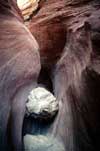 It lies between St. Catherine's Monastery and the town of
Nuweiba. It is a natural formation of sandstone and limestone of
various colours worn away over the centuries by rains draining
from the mountain top. Exquisite patterns have been formed of a
myriad colours forming patterns of all shapes and sizes. Some
resemble woodgrain – others surrealism paintings – but these are
note man made. Different shapes and colours greet you upon every
turn. It lies between St. Catherine's Monastery and the town of
Nuweiba. It is a natural formation of sandstone and limestone of
various colours worn away over the centuries by rains draining
from the mountain top. Exquisite patterns have been formed of a
myriad colours forming patterns of all shapes and sizes. Some
resemble woodgrain – others surrealism paintings – but these are
note man made. Different shapes and colours greet you upon every
turn.
It has become a popular safari trek and The strange rock
formations and the rainbow- hued colored canyon walls are
dramatic and the silence within -only adds to the oddity. Great
for walking or rock-climbing
Serabit El Khadem
While the Egyptians seem to have known, crossed and visited the
Sinai even before the dynastic period, we have found little
evidence of their building activities in the region. Of course,
inhabitable areas are usually small, and scarce, and so have
been inhabited and built upon continuously over the ages. It is
probable that what was built has been built over many times.
Today, wondering through the Sinai and viewing its unusual
landscape, it is not difficult to imagine a land rich in
minerals. Egyptians discovered its mineral wealth very early on,
perhaps at the beginning of the dynastic period. Archaeologists
have found that the very earliest known settlers in the Sinai,
about 8,000 years ago, were miners. Drawn by the region's
abundant copper and turquoise deposits, these groups slowly
worked their way southward, hopping from one deposit to the
next. By 3500 BC, the great turquoise veins of Serabit el-Khadem
had been discovered.
 The ancient mining complex of Serabit el-Khadem lies on a small
plateau north of modern Al-Tor. It is located about halfway down
the western coast about ten miles from Wadi Mughara. It was one
of the most important sites for the Egyptians on the peninsula.
Today, it is not difficult to reach the Serabit el-Khadem area,
though the trip must be made by jeep. There are no paved roads
to the base of the mountain. Although many of the region's
pharaonic reliefs were destroyed by a British attempt to re-open
the mines in the mid-nineteenth century, along the path to the
temple are a number of engravings that were written by the
ancient minors. Some of the most interesting portray the ships
that would carry the turquoise to Egypt. There is also an
excellent bas relief of King Sekhemkhet on the east face of the
plateau, revealing him smiting Egypt's enemies. Other
antiquities are found along the path, including ancient tunnels,
miner's huts and stele. The ancient mining complex of Serabit el-Khadem lies on a small
plateau north of modern Al-Tor. It is located about halfway down
the western coast about ten miles from Wadi Mughara. It was one
of the most important sites for the Egyptians on the peninsula.
Today, it is not difficult to reach the Serabit el-Khadem area,
though the trip must be made by jeep. There are no paved roads
to the base of the mountain. Although many of the region's
pharaonic reliefs were destroyed by a British attempt to re-open
the mines in the mid-nineteenth century, along the path to the
temple are a number of engravings that were written by the
ancient minors. Some of the most interesting portray the ships
that would carry the turquoise to Egypt. There is also an
excellent bas relief of King Sekhemkhet on the east face of the
plateau, revealing him smiting Egypt's enemies. Other
antiquities are found along the path, including ancient tunnels,
miner's huts and stele.
The temple at Serabit el-Khadim, though really only scattered
ruins, is one of the few phraonic monuments we know of in the
Sinai. Here it was found the famous proto-Sinaitic script",
which is believed to be an early precursor of the alphabet.
These scripts were hieroglyphic signs used to write the names of
the West Semitic names of the people who worked the mines, and
keep account of their labors. They developed an alphabet with
which they could record their Proto-Canaanite language. The
script they developed is called Proto-Sinaitric (First-Sinaitic)
and the language was a Pan-Canaanite language often called Old
Hebrew
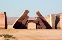
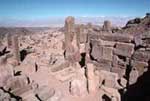 The Serabit El Khadim temple looks like a double series of
steles leading to an underground chapel dedicated to the Hathor
Goodness. Most of the temple’s large number of sanctuaries and
shrines were dedicated to Hathor, among her many other
attributes; she was the patron goddess of copper and turquoise
miners. It is the only temple we know of, built outside mainland
Egypt and mostly dedicated to Hathor. The earliest part of the
main rock cut Hathor Temple, which has a front court and
portico, dates to the 12th Dynasty The temple was probably
founded by Amenemhet III, during a period of time when the mines
were particularly active. The 12th Dynasty was a period of
considerable mineral wealth for Egyptians and some of the finest
jewelry from Egypt's past have been discovered in the tombs of
12th Dynasty women. The Serabit El Khadim temple looks like a double series of
steles leading to an underground chapel dedicated to the Hathor
Goodness. Most of the temple’s large number of sanctuaries and
shrines were dedicated to Hathor, among her many other
attributes; she was the patron goddess of copper and turquoise
miners. It is the only temple we know of, built outside mainland
Egypt and mostly dedicated to Hathor. The earliest part of the
main rock cut Hathor Temple, which has a front court and
portico, dates to the 12th Dynasty The temple was probably
founded by Amenemhet III, during a period of time when the mines
were particularly active. The 12th Dynasty was a period of
considerable mineral wealth for Egyptians and some of the finest
jewelry from Egypt's past have been discovered in the tombs of
12th Dynasty women.
 A number of scenes portray the role of Hathor in the
transformation of the new king, upon ascending the throne, into
the deified ruler of Egypt. One scene, for example, depicts
Hathor suckling the pharaoh. Another scene from a stone tabled
depicts Hathor offering the pharaoh the Ankh. A number of scenes portray the role of Hathor in the
transformation of the new king, upon ascending the throne, into
the deified ruler of Egypt. One scene, for example, depicts
Hathor suckling the pharaoh. Another scene from a stone tabled
depicts Hathor offering the pharaoh the Ankh.
This older part of the temple was enlarged upon and extended by
Queen Hatshepsut, along with Tuthmosis III and Amenhotep III
during the New Kingdom. This was a restoration period for the
mining operations after an apparent decline in the area during
the Second Intermediate Period. These extensions are unusual for
a temple in the manner in which they angled to the west off of
the earlier structure.
On the north side of the of the temple is a shrine dedicated to
the pharaohs who were deified in this region. On one wall of the
shrine are numerous stele. A little to the south of the main
temple we also find a shrine dedicated to the god of the eastern
desert, Sopdu, which is smaller then the northern shrine.
Oyun Musa
 Oyun Musa or “Springs of Moses” is located about 16 miles south
of the Ahmed Hamdi Tunnel, which connects the mainland Egypt
with Sinai. It is believed that this is the Springs of Moses.
Moses is said to have, upon the advice of God, thrown a special
tree into the brackish water which made it drinkable. Today the
spring is still brackish, and there is no tree in sight, but
seven of the original 12 springs still exist. During the Egypt
Expedition we know that there were nine springs still active. At
one point during the 19th century, this, the largest of the
Sinai Oases, became a popular retreat for foreign diplomats.
There is a small community that has grown up around the springs. Oyun Musa or “Springs of Moses” is located about 16 miles south
of the Ahmed Hamdi Tunnel, which connects the mainland Egypt
with Sinai. It is believed that this is the Springs of Moses.
Moses is said to have, upon the advice of God, thrown a special
tree into the brackish water which made it drinkable. Today the
spring is still brackish, and there is no tree in sight, but
seven of the original 12 springs still exist. During the Egypt
Expedition we know that there were nine springs still active. At
one point during the 19th century, this, the largest of the
Sinai Oases, became a popular retreat for foreign diplomats.
There is a small community that has grown up around the springs.
Ras Mohamed
Ras Mohamed is located at Gulf of Aqaba on an area of 480 square
kilometers .
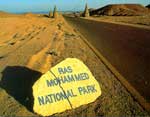 It is the headland at the southern most tip of the Sinai
Peninsula, overlooking the juncture of the Gulf of Suez and the
Gulf of Aqaba. The islands of Tiran and Sanafir are part of the
site. Littoral habitats include a mangrove community, salt
marshes, inter-tidal flats, a diversity of shoreline
configurations and coral reef ecosystems that are
internationally recognized as among the world's best. In
addition a diversity of desert habitats such as mountains and
wadis, gravel plains and sand dunes. It is the headland at the southern most tip of the Sinai
Peninsula, overlooking the juncture of the Gulf of Suez and the
Gulf of Aqaba. The islands of Tiran and Sanafir are part of the
site. Littoral habitats include a mangrove community, salt
marshes, inter-tidal flats, a diversity of shoreline
configurations and coral reef ecosystems that are
internationally recognized as among the world's best. In
addition a diversity of desert habitats such as mountains and
wadis, gravel plains and sand dunes.
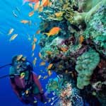 More than 200 species of corals, where 125 species are soft
corals, around 1000 species of fish, 40 species of star fish, 25
species of sea urchins, more than a 100 species of mollusc and
150 species of crustaceans. More than 200 species of corals, where 125 species are soft
corals, around 1000 species of fish, 40 species of star fish, 25
species of sea urchins, more than a 100 species of mollusc and
150 species of crustaceans.
Ras Mohammed is important as a
bottleneck for migratory soaring birds. The majority of the
world populations of white stork Ciconia ciconia pass through
this area. The islands of Tiran and Sanafir hold important
breeding populations of the threatened and endemic White-eyed
Gull Larus leucophthalamus and Osprey Pandion haliaetus. The
island of Tiran has one of the largest recorded Osprey
populations in the Red Sea. The threatened Green Turtle Chelonia
mydas and Hawksbill Turtle Eretmochelys imbricata occur off Ras
Mohammed regularly. The threatened mammal species include Dorcas
Gazelle Gazella dorcas, Nubian Ibex Capra ibex nubiana
 Tourism in Southern Sinai is inherently linked to the natural
resources of the area. Degradation of these natural resources as
a result of tourism or development activities is not in the best
interests of investors or tourists.The Protected areas program
seeks to establish equilibrium between development activities,
tourism and the natural resource conservation measures needed to
achieve sustainable economic development. Tourism in Southern Sinai is inherently linked to the natural
resources of the area. Degradation of these natural resources as
a result of tourism or development activities is not in the best
interests of investors or tourists.The Protected areas program
seeks to establish equilibrium between development activities,
tourism and the natural resource conservation measures needed to
achieve sustainable economic development.
 Due to Ras Mohamed’s geographical position, divers find almost
permanent strong currents during all the year, which attracts
larger fish. Beautiful beaches, extraordinary coral reefs and
exciting dive sites make Ras Mohamed National Park a worthwhile
visit. Due to Ras Mohamed’s geographical position, divers find almost
permanent strong currents during all the year, which attracts
larger fish. Beautiful beaches, extraordinary coral reefs and
exciting dive sites make Ras Mohamed National Park a worthwhile
visit.
Coral reef ecosystems found in the National Park are recognized
internationally as among the world's best. This recognition is
based primarily on the diversity of flora and fauna, clear warm
water devoid of pollutants, their proximity to shorelines and
their spectacular vertical profile. The reef exists as an
explosion of color and life in stark contrast to the seemingly
barren desert adjacent to it. In reality, the desert is rich in
fauna, mainly nocturnal. These ecosystems are intrinsically
linked and thus must be managed as a single unit.
The National Park offers outstanding coral reef and nature
viewing experiences to the visitor.
Firan oasis
Over 12,000 palm trees, monastic remains, and access to Jebel
Serbal. Wadi Firan may have been the route taken by the
Israelites to reach Mount Sinai.
Geziret Faraoun
There are a number of forts in Egypt. The most famous of these
is the Citadel in Cairo, but also notable is Fort Qaitbey in
Alexandria, built on the location of the legendary Pharos
Lighthouse. Probably the least known of the major forts is
located on Pharaoh's Island in the Gulf of Aqba. This fortress
would undoubtedly draw much larger crowds of tourists were it
located in a more mainstream tourist destination, but tourists
who make an effort to visit the fort will usually have the
island mostly to themselves.
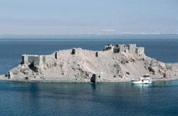 Pharaoh's Island, sometimes called Coral Island, or Geziret
Faraoun, is the location of a Crusader fortress originally built
by Baldwin I, the King of Jerusalem. From the top of the
fortress, one can see four countries, including Egypt, Israel,
Jordan and Saudi Arabia. Work apparently began on the fortress
around 1116 AD. Baldwin built the Fortress for three reasons:
First it was in the center of a huge trade route between the far
East and Europe, second it was easily defendable, being out of
range of land based catapults and was on high ground and third
it was in the narrowest section of the Gulf of Aqaba. Pharaoh's Island, sometimes called Coral Island, or Geziret
Faraoun, is the location of a Crusader fortress originally built
by Baldwin I, the King of Jerusalem. From the top of the
fortress, one can see four countries, including Egypt, Israel,
Jordan and Saudi Arabia. Work apparently began on the fortress
around 1116 AD. Baldwin built the Fortress for three reasons:
First it was in the center of a huge trade route between the far
East and Europe, second it was easily defendable, being out of
range of land based catapults and was on high ground and third
it was in the narrowest section of the Gulf of Aqaba.
At various times while in Crusader hands, it was used to collect
taxes on Arab merchants, and sometimes to attack Arab shipping,
while at the same time protecting pilgrims traveling between
Jerusalem and St. Catherine's Monastery. The fortification was,
however, captured by Salah ad-Din in about 1170. He expanded the
fortress considerably and that it was possibly not abandoned
until the 13th century and the Mamelukes and Ottomans probably
further enhanced it.
The fortress, which is completely renovated, has many small
rooms some with arched doorways and other without. These rooms
included sleeping quarters for the troops, bath houses and
kitchens with huge ovens . There are towers to house carrier
pigeons, which were used for relaying messages in the Middle
Ages and circular towers for archers.
Little else of the Fortress history is known. Obviously at least
one important battle took place there, when Salah ad-Din took
the Fortress from the Crusaders, but beyond that we really here
of no major battles involving the fort. |